
Description of Regions:
Copper Canyon - Baja California - Archaeological Zones - Magical Towns - Colonial Cities
In the glossary by cities you will find a summary of the places, activities and events that are worth visiting, which we include in our travel programs. The glossary is divided by region. In case you have any questions, do not hesitate to contact us.
Copper Canyon
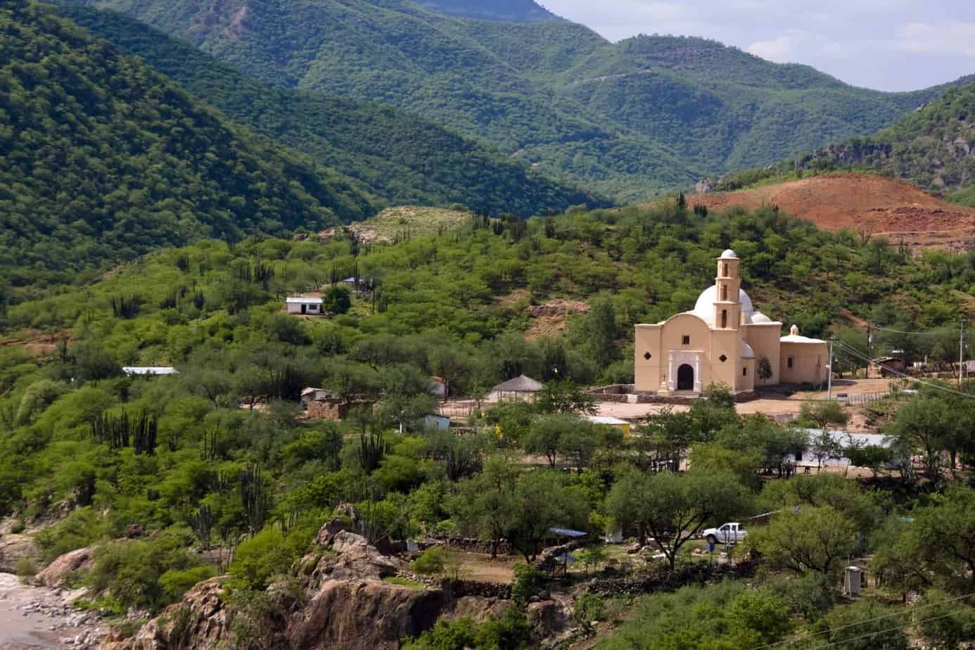
Bahuichivo is one of the Chepe stations and from here you can reach the town of Cerocahui, which is 30 minutes away and is 1,600 m. Tall.
Cerocahui was founded in 1690 by the Jesuit priest Juan Maria de Salvatierra who established Mission San Francisco Xavier here. It is said that he was one of the first to explore the bottom of the Urique Canyon.
Cerocahui is one of the most peculiar and picturesque towns in the Sierra Tarahumara, it gives the impression that little has changed since the arrival of the Jesuits, because it is still a town without agitation and stress.
The area around Cerocahui is a true paradise for trekking, hiking to the Huicochi waterfall, horseback riding or visiting the Urique Canyon viewpoint.
From Cerocahui you can visit the town of Urique which is at the bottom of the canyon in a relatively short time. On the way you will see some ranches of the inhabitants, mostly from Raramuris families. Experience how the landscape with conifers gradually changes as you descend into a tropical landscape with palm trees. In the town of Urique we recommend cooling off in the river and walking through the small boulevard and plaza. If you want to make this interesting excursion, you must plan at least two nights in Cerocahui since this tour requires a whole day.
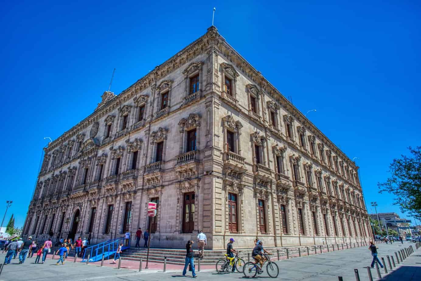
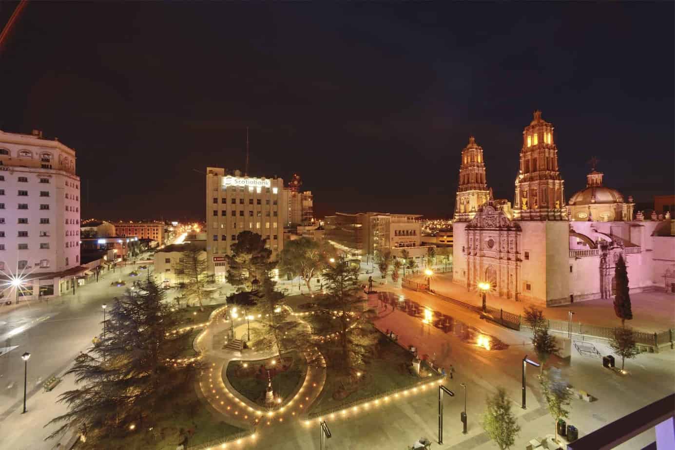
Chihuahua is the capital of the state of the same name. It is not only the largest state, but also one of the richest states in Mexico due to cattle breeding, mining and the timber industry. The city is located at 1,440 m and has 247,087 km2
Chihuahua was founded by Spanish missionaries in 1709. Despite the distance to the capital Mexico City, the city played an important historical role several times, especially as a refuge and retreat for disempowered politicians.
In 1811, Miguel Hidalgo Priest – father of the Mexican independence movement – was arrested by Spanish troops after his flight to the north, sentenced to death and shot in Chihuahua.
Benito Juarez, Mexican President of 1858-1863 and 1867-1872, stayed in Chihuahua frequently after he was deposed in 1863 and replaced by the Austrian Emperor Maximilian. There he successfully planned resistance to the Empire, which ended with the overthrow of Maximilian.
The most prominent guest of Chihuahua, however, was undoubtedly Pancho Villa. He often visited the city during the Mexican Revolution from 1910. If you want to get more information about Pancho Villa and his deeds, you should visit the Museum of the revolution in Chihuahua. In addition to various profiles that were used to search for Pancho Villa, the car, where you can see some personal object as well as the car in which he was shot. We recommend taking a walk through the historic center and visiting the Cathedral, a baroque marvel that dates back to 1725. In the area of the cathedral you should not miss a visit to the Museum of Sacred Art. In front of the cathedral is the “Plaza de Armas” and the Municipal Palace where you can see the murals of Aaron Piña about the history of Chihuahua.
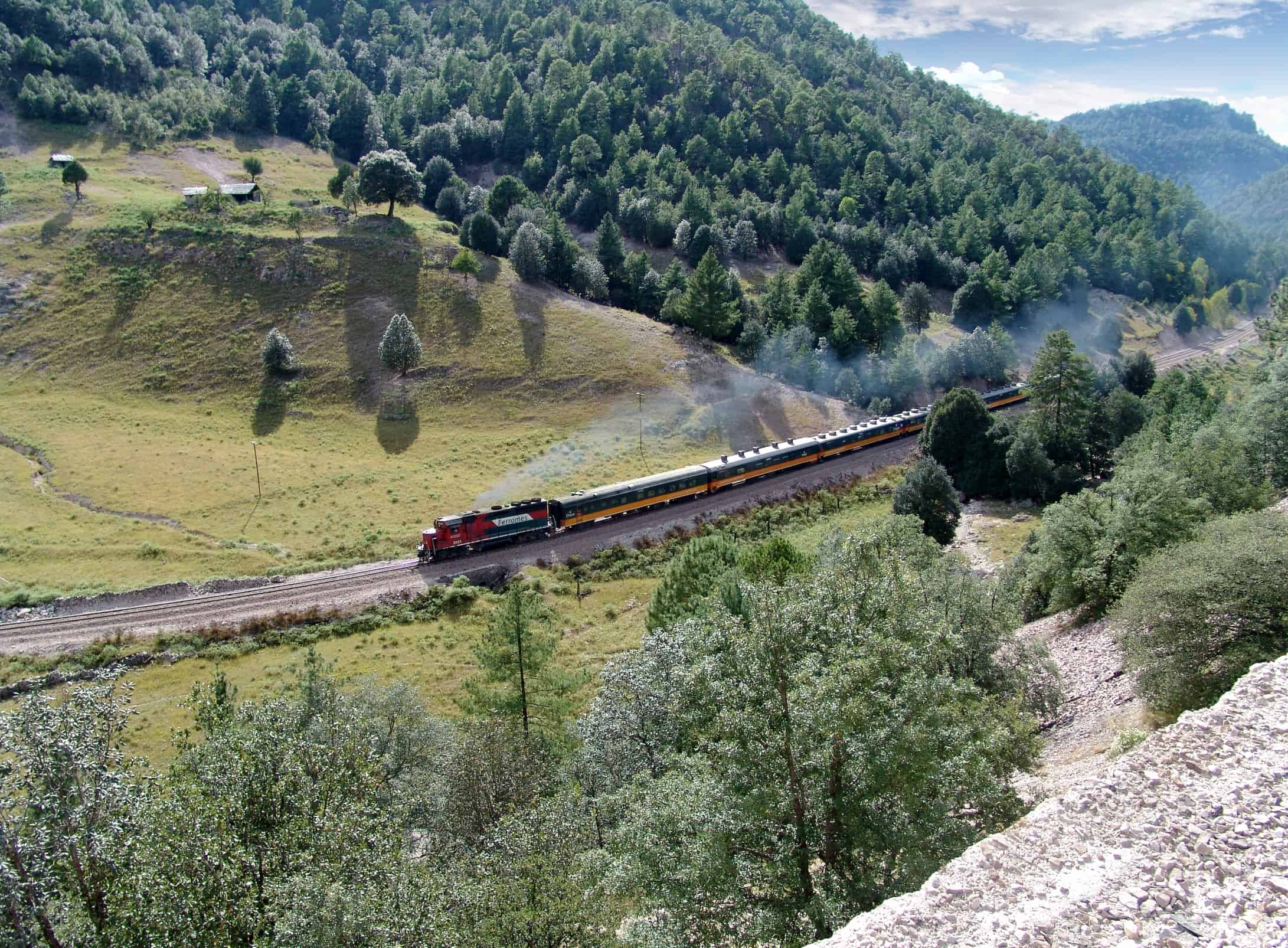
Creel was founded in 1907, during the first stage in the construction of the railway from Chihuahua to the Pacific. It became a small town and is now the largest and most important mestizo settlement on the railway line. The city has the character of a gold mining town. For a brief moment, you could almost forget to be in Mexico.
Creel is the gateway to Copper Canyon and the Magical town of Batopilas.
Jesuit priest Luis Verplancken, has been running aid programs for the indigenous Tarahumara for years. That is why this place is often considered as the meeting place of the Tarahumaras. It is only thanks to the tireless efforts of the priest that the Indians have three hospitals in the Creel area, where they are treated almost free of charge. The hospitals are funded by donations and proceeds from the Tarahumara items sold in the mission store next to the church.
Creel was named “Pueblo Mágico” in 2007. This is a ver y special appointment that the Federal Secretary of Tourism grants to towns with magic, culture and history.
Creel has numerous hotels, restaurants, and souvenir shops. Various excursions are offered: you can ride on horseback, rent mountain bikes, participate in various day trips or simply explore the city. The locals or the indigenous Rarámuris gather in the Plaza Mayor to sell their handmade crafts to the tourists.
You can do several excursions from Creel:
- Arareko lake, this beautiful lake is 7 km southeast of Creel, on the road to Cusárare. It has an area of 40 hectares and a length of 3 km. It is one of the most charming places in the area. It is surrounded by both dense pine and oak forests and is inhabited by a rich wildlife. On the lake you can go for a walk, ride a horse or ride a bike. If you want, you can also go on a tour with a rowboat.
- The Cusárare waterfall is located 22 km south of Creel near the town of the same name. It is 30 m high and looks like a waterfall surrounded by mountains covered with extensive pine forests
- The Cusárare Mission was founded by Jesuits in the mid-18th century. It still conserves a large part of the original architecture. Inside, the Tarahumara paintings from the 16th and 18th centuries. The mission celebrates the most important festivals in the community, such as easter week
- The main attractions in this region are the two largest waterfalls in Mexico. This is the Basaseachi with a drop of 246 m and the Balancing Rock with 453 m. These waterfalls can be seen from different points of view.
- The Candameña Canyon is located at the foot of the Basaseachi waterfall. This barranca is still relatively unknown because it is very difficult to access.
- From Creel you can also visit the Barranca Batopilas (123 km). It is 1,750 m deep and also known as “La Bufa”. This is the old name of the gold and silver mine that made Batopilas a glamorous place. It was founded in 1708 after the discovery of silver deposits.
- Here is also the silver Route which is 225 km long and begins in Chihuahua. Drive through the “heart” of the Sierra Tarahumara to the old Batopilas silver mine. More than a million ounces of silver were mined in the 19th century. The silver was transported on donkeys to Chihuahua in 7-8 days. The animals carried up to 25 kg of silver and traveled 40 km per day.
The road was heavily traveled until the silver mine was closed. Today you can rediscover this route on foot, by bike or on horseback.
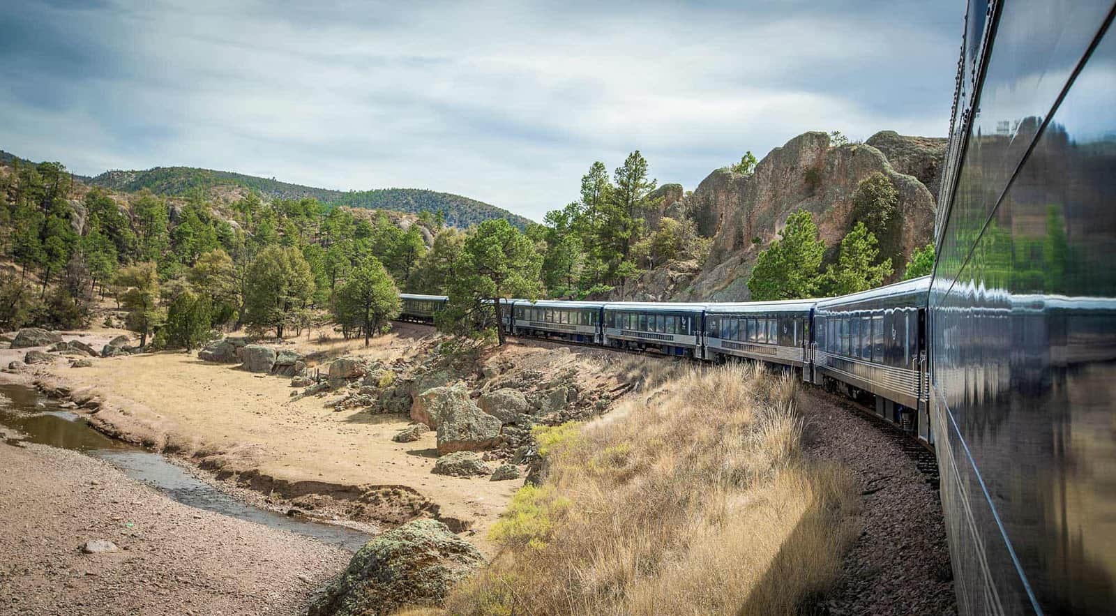
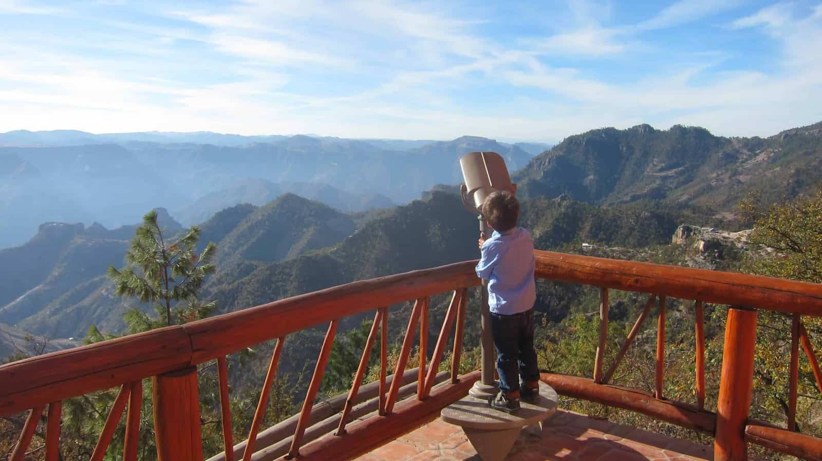
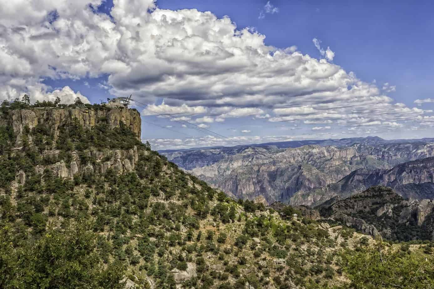
This stop is at an altitude of 2,200 m and 10 minutes from the Divisadero station. Between Posada Barrancas and Divisadero is the Copper Canyon Adventure Park with the longest cable car in Mexico.
The adventure activities like the cable car, Ziprider and zip lines were built by an Austrian company. From any part of this infrastructure you can appreciate an incomparable panoramic view over three of the most important canyons in the system: Cobre, Urique and Tararecua. The Tarahumaras or Rarámuris inhabit this region. At 5 minutes walking you can visit the picturesque church of the town of Areponapuchic.
This stop is located exactly in the middle of the railway line between Los Mochis and Chihuahua at an altitude of 2,200 m and almost on the edge of the ravines from where you can see a spectacular view.
This is where three of the largest canyons are located, the Urique, Cooper and Tararecua canyons.
The train stops at Divisadero for 15 minutes so that travelers can get off the train and take photos of the canyons and or buy handicrafs sold by the Tarahumara.
You can also try a traditional Mexican food, the “Gorditas”. These are corn tortillas stuffed with vegetables or meat.
A few kilometers away is the National Park where you can take a ride over the canyons by cable car or Ziprider. The gondolas can accommodate up to 60 passengers.
This beautiful colonial city located on the banks of the Fuerte river is curiously unknown to international travelers. Historically, El Fuerte is one of the most important and interesting cities in northern Mexico. It has an old town characterized by the Spanish colonial style and is firmly rooted in culture with the indigenous Yoreme traditions. On the route from Los Mochis to Chihuahua, El Fuerte is the first stop of the “CHEPE”. The city is located about 80 km northeast of Los Mochis.
El Fuerte was founded in 1564 by the Spanish Francisco de Ibarra as “La Villa de San Juan Carapoa”. The first Jesuits arrived in the region in the late 16th century.
The safe and untamed natives of the area initially rejected Christianity and paid little respect to the Spanish. to be safe from the constant Indigenous attacks, the conquerors built a fort in the early 17th century. Since then, this city has been known as El Fuerte.
During the 18th century, Spaniards came to El Fuerte to explore what are now the states of California and Arizona and to stock up on supplies. During this time, the city became an important commercial center. It was a traffic junction where treasures and merchandise were transported on the legendary “Camino Real” route (between New Mexico in the United State and Mexico City).
In 1824, after Mexico gained independence from Spain – El Fuerte became the capital of what was then the Western State, which corresponded to the current states of Sinaloa and Sonora and reached north to the Grand Canyon in what is now the state of Arizona.
At the beginning of the century, prominent figures of the Mexican Revolution such as Francisco I. Madero or Venustiano Carranza visited this city and in 1915 during the Mexican Revolution the city was even the scene of a battle.
The great decisive moment for El Fuerte occurred 1952 with the construction of the Miguel Hidalgo hydroelectric plant, which was followed in 1965 by another with the name Josefa Ortiz de Dominguez and a few years later in 1996 with the name of Luis Donaldo Colosio (popularly known as Presa Huites). These structures helped the region to boom.
The reservoirs are interesting excursion destinations from El Fuerte. Other attractions are the wall inscriptions or petroglyphs up to 1,500 years old that have been found in the area. The hill of the Mask comprises approximately 45 stones, which together have more than 100 engravings. These stones are 800 to 2,500 years old. You can also visit the ruins of the Jesuit mission stations.
The Yaqui and Yoreme Indigenous still live in the region around El Fuerte, who, like the Tarahumaras, have preserved a traditional lifestyle, such as the town hall, the kiosk, the museum and some old houses.
El Fuerte was named “Magic Town” for its colonial charm, culture and history.
The city of Los Mochis is 15 kilometers from the Pacific coast and is currently the center of a very fruitful agricultural irrigation zone. It was discovered in 1533 by the Spanish conqueror “Diego de Guzmán” and was inhabited by indigenous people from the Tehuecos, Zuaques and Ahomes tribes.
The city was founded at the end of the 19th century. The growth of the city occurred when the American Benjamin Johnston built a sugar factory, which played an important role in the development of the city. Well, the first settlements that contributed to economic growth were established. In 1903 this human settlement reached the appointment of city.
Los Mochis is a modern city and it does not have old or historical buildings. In the Regional Museum you can find images of how were the beginnings of this city. The Botanical Garden you will find a collection of trees and plants brought from all over the world.
During your visit we invite you to taste the delicious seafood and to be pampered by the warmth of the people who welcome you with open arms.
15 km away is Topolobampo Bay in the Gulf of California. The third deepest natural bay in the world. We suggest taking a yacht ride through the bay visiting the Island of Birds, to observe a variety of endemic birds. During the walk it is very likely that you will also see dolphins. Another interesting visit “El Maviri” beach to rest or taste the famous “Pescado Zarandeado” or the giant shrimp.
Los Mochis is not only the starting or ending point of the train trip to the Copper Canyon. From here you continue in all directions. Domestic flights connect Los Mochis with Mexico City and cities in the United States, such as Los Angeles in California or Phoenix in Arizona.
The small town of La Paz in Baja California is reached every day from Topolobampo by ferry (Baja Ferries) across the Gulf of California. The trip by sea lasts approximately 7 hours.
Another connectivity that Los Mochis offers is to Baja California flying to La Paz or Los Cabos, an attractive coastal city at the southern tip of the peninsula, which is served daily by local airlines.
At the beginning of the last century, the construction crews of the railway line were shocked when they entered the canyons and discovered an indigenous tribe that still seemed to live in the Stone Age. Because the indigenous Tarahumaras, called among themselves Rarámuri, repeatedly withdrew to the mountainous region of the Sierra Madre to escape Spanish civilization or conquerors, they are often called the indigenous tribe most primitive of America due to its way of life.
Some Tarahumara now live near the train stations, where they sell artisan items such as
baskets, dolls, or pottery to travelers when trains arrive. For the Rarámuris, this is income for
help their families.
However, most of the Tarahumara still live apart from civilization in the canyons and tend their ranches in the middle of nowhere. During the summer months they are found in the higher regions, where they grow corn and raise animals (mainly goats and chickens). Many traditionally live in caves. In the winter months they move to the lower and warmer ravines. There they live in huts made of mud, stone or wooden houses.
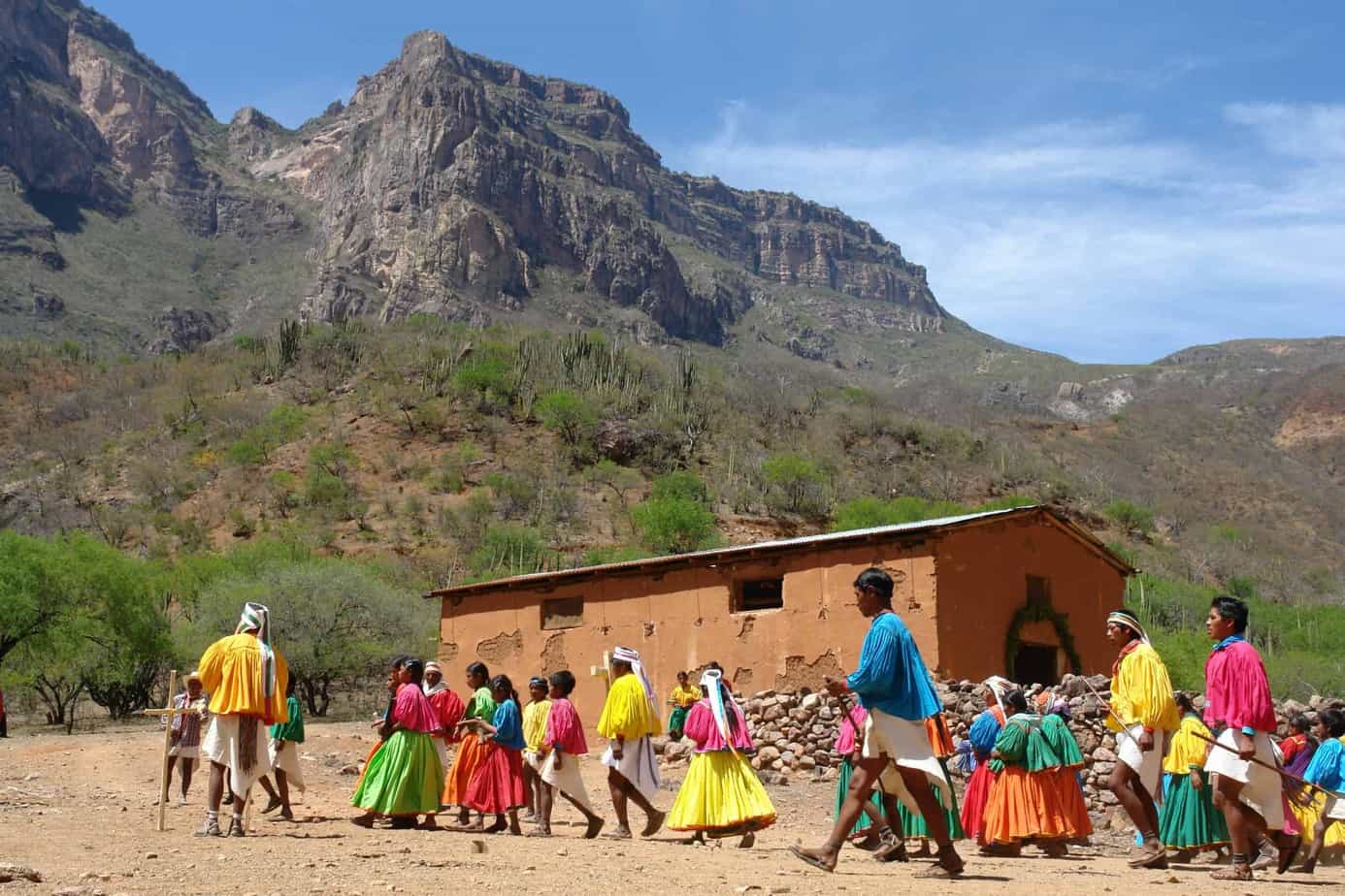
The Tarahumara have excellent running condition and like to test themselves during local festivals. Running a hundred kilometers is nothing unusual for them as they are used to running long distances on a daily basis. This is even more surprising when on the rugged roads between races a small wooden ball is kicked in front of them, they so-called “Rarájipare” judge for men and “La Arigueta” for women.
The Tarahumara, mostly short in stature, often go barefoot even in winter. Typical women’s clothing is colored patterned skirts and they wear a red headband or headscarf. The men wear a white shirt and a loincloth. Her long hair is attached by a headband.
The Tarahumara live very simply in small settlements. Foreigners often perceive them as very shy and reserved. But among themselves and their relatives, they are very cheerful, kind and helpful to their fellow men.
The Raramuris never fully adopted Christianity. Therefore, their religion is a combination of old traditional rites and Catholicism. This is very well expressed in your celebrations. The largest festival takes place on Easter week.
They make their music with instruments made of wood by themselves such as tambourine, drum, flute and a kind of violin. The elaboration of these instruments is transmitted from generation to generation, as well as the typical dances. At festivals, an alcoholic beverage made from fermented corn, called “Tesgüino” is drunk.
The festivities are a way to meet and celebrate with people from neighboring towns.
The Sierra Madre consists of two mountain ranges that rise up to 3,600 meters and enclose the mountains more high from Mexico.
In eastern Mexico, the Sierra Madre Oriental stretches from north to south, in the west towards the Pacific is the Sierra Madre Occidental which stretches around 1,300 km.
While the mountains in eastern Mexico consist primarily of limestone, the Sierra Madre Occidental in the northwest was created by volcanism.
30-60 million years ago, during the Tertiary Era, there was intense volcanic activity associated with the collision of the Pacific and North American plates. That was “the birth” of the Sierra Madre Occidental.
Over a period of almost 10 million years, millions of tons of ash and rocks were expelled from volcanoes. Formation of deposits up to 3,000 m thick, which over time were pressed to form different layers.
Other tectonic movements created large cuts in the earth’s surface in this area. Many of them sank up to 1,500 m, forming crevices and ravines. The steep rock faces that can be seen today are made of hard rock and were able to resist erosion. Large amounts of rain created underground streams, as well as streams and rivers, some of which still flow between the canyons today.
Welcome to the Sierra Tarahumara
What is often referred to as the Copper Canyon or “Barranca del Cobre” is actually called the Sierra Tarahumara.
This approximately 25 million year old area in the northern Sierra Madre Occidental comprises a system of several large and small canyons, of which the Copper Canyon is the best known. Together they form what is believed to be the largest canyon system in the world, which is approximately 60,000 square kilometers in area, around four times the size of the famous Grand Canyon / Colorado Canyon in Arizona / USA.
(Another comparison: Bavaria = 70,550 km2). The ravines of the Sierra Tarahumara are in several places up to 400 m deeper than the Colorado Canyon. Its maximum height is approximately 3300 m, the lowest point is 220 m above sea level.
However, since the Sierra Tarahumara has never been measured exactly, such figures cannot be obtained with certainty.
Of the multitude of canyons, we present below the best known for their beauty:
- The Copper Canyon is 1,760 m deep. It connects to the Tararecua and Urique canyons.
- The Barranca Urique with 1,879 m depth with the Urique River that flows into the Fuerte River.
- The Barranca de Batopilas with 1,800 m depth. It is connected with the Canyon de la Bufa and Munérachi. The Winding and steep “Camino de la Plata” leads to the old silver mine that existed in Batopilas.
- The Barranca de Sinforosa with 1,830m depth through which the Río Verde flows.
- The 1,600m deep Barranca de Chínipas, which was shaped by the Chínipas River.
- The Barranca Candameña with 1,750m depth. Here is the second highest waterfall in the region, Basaseachi with 246 m.
Don’t think that the Sierra Tarahumara is as big as the Grand Canyon! Anyone who comes up with the idea of finding rock formations in desert colors will be disappointed. The Sierra Tarahumara resembles a green “oasis”, especially after the rainy season from June to September and therefore impresses is much more impressive for its natural beauty. One of the most amazing impressions is that you can never see the bottom of the Barrancas, this due to the extension and depth they have. You often feel small and helpless in front of this gigantic natural coliseum!
The Sierra Tarahumara fascinates with its diverse flora and fauna, which varies according to altitude.
You can find fir trees at higher altitudes. followed by an area covered with oak and pine forests, followed by the area of walnut and juniper plants.
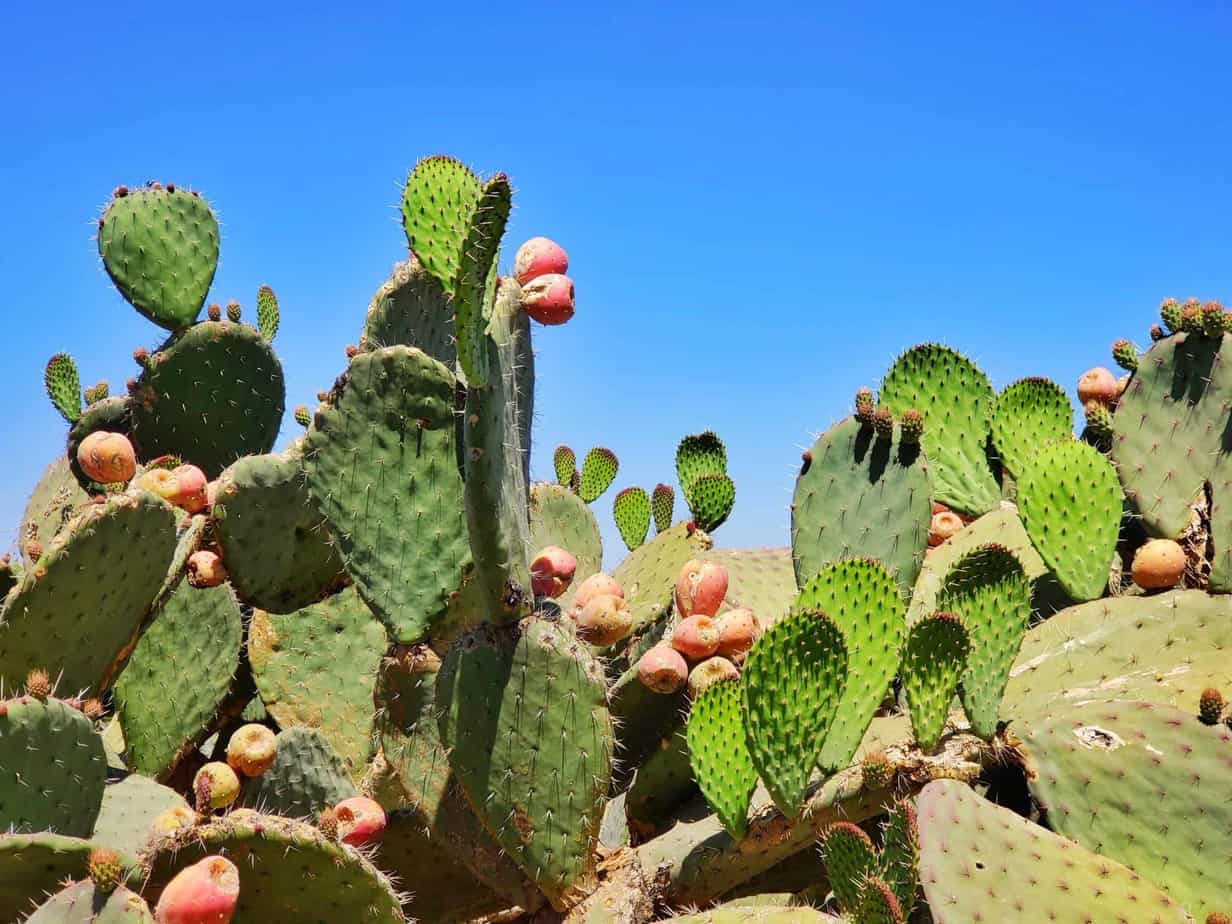
Below 1,500 m, arid thorn forests begin with cacti, agaves, mosques and acacias.
Tropical plants such as mangoes, bananas or citrus trees grow at the bottom of the ravines.
While bears, beavers, and cougars are endangered and therefore rarely found, the eagle that swings majestically over the ravines. The Sierra Tarahumara is home to numerous other species of birds, insects, reptiles, and amphibians.
The unique combination of flora and fauna, the approximately 50,000 indigenous Tarahumara, and the rugged mountain world give this region in the two states of Sinaloa and Chihuahua a touch of uniqueness and originality.
– Welcome to the Sierra Tarahumara!
In general, it is believed that the American continent began to be populated about 50,000 years ago and that its inhabitants were of Asian origin, who in small clans in search of new territories and hunting habitats crossed the Bering Strait. These small ethnic groups moved south from Alaska at a speed of about 20 kilometers per generation. After all, some 21,000 years ago they arrived in what we now call Mexico.
These people, who were hunters and gatherers, spread throughout Mexico throughout time. Due to favorable external conditions, advanced cultures such as those of the Olmecs or the Mayans emerged in some regions, to name just two. (If you want to learn more about pre-Hispanic cultures, you should definitely plan on your trip to Mexico a visit to the Museum of Anthropology.)
However, the harsh desert climate of northern Mexico with its differences in climate and extreme temperatures forced people more than in other regions to a nomadic way of life. The existence of such nomadic tribes in northern Mexico dates back to about 10,000 years before our era. The only known archaeological site of high culture in northern Mexico is Paquimé (also known as Casas Grandes) in the state of Chihuahua,
it flourished between 900 and 1200 AD. At that time, Paquimé had multi-story buildings, pyramids, and an irrigation system for the surrounding land. Due to the finds, such as necklaces made of shells, jade and pearls, it must be assumed that Paquimé had commercial relations with other ethnic groups. Around 1340 BC This city was burned down, perhaps by nomadic Apaches.
With the Spanish conquest of Mexico in 1521, the American continent began to change. However, this did not happen at the same rate everywhere. Thus, the inhospitable north and the completely unknown Sierra Tarahumara and ethnic groups were kept safe from the “Conquest” for a long time. Only a few Europeans invaded this area. Among them was the Spanish conqueror Álvaro Núñez Cabeza de Vaca, who spread the rumor of seven northern cities with large deposits of gold and silver. Another Spaniard, Francisco Vázquez de Granada, was able to confirm the existence of these settlements. The young and ambitious Francisco de Ibarra began with the colonization of northern Mexico and with it the founding of new cities.
The fundamental basis of the constant colonization of the Mexican north was given with the arrival of the Jesuits, who arrived at the end of the 16th century and, during their almost 200 years of missionary activity, settled not only in northern Mexico but also in what is now the US state of Arizona, New Mexico and Texas.
The first missionaries learned that converting the Indians to the new Catholic faith was not easy. The natives considered all the conquerors as enemies due to the bad experiences they had since their arrival. Jesuit priests were the first victims of the Tarahumara rebels.
Despite such setbacks, it was always the missionaries who defended the rights of the indigenous people. When the Jesuits were expelled from New Spain, as Mexico was known then, by decree of the Spanish king in 1767, the Tarahumara were left unprotected.
Over time, more and more Spaniards came to the country and forced the local population to work in the silver mines. To survive, the Tarahumara withdrew taking refuge in valleys and mountains that were difficult to access, where many of them still live far from civilization.
Baja California
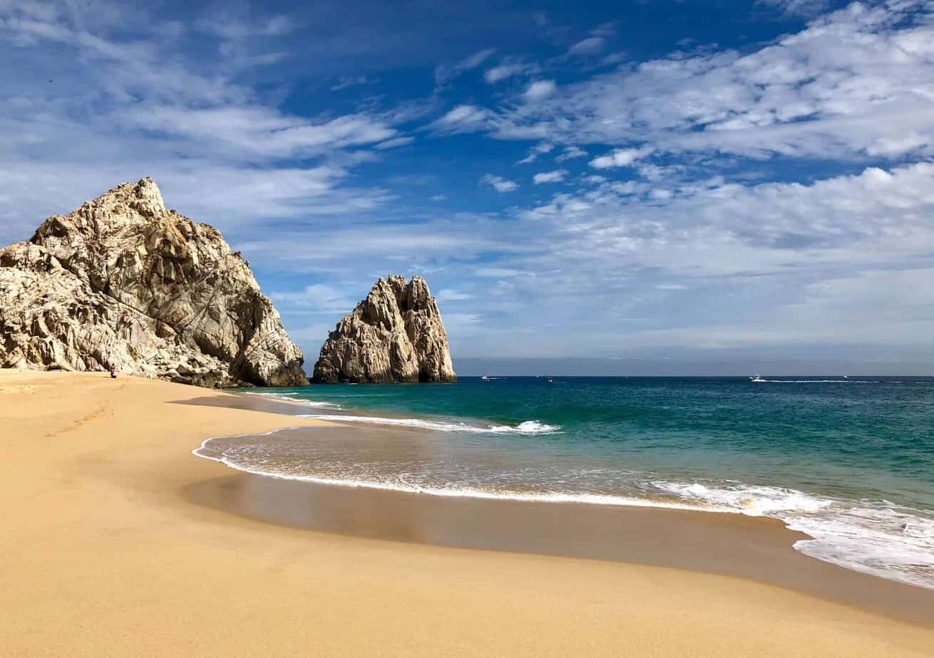
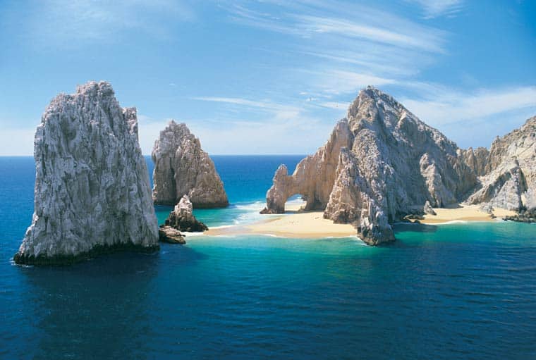
Cabo San Lucas is a seaside resort at the southern tip of the Mexican Baja California peninsula, known for its beaches, water sports, and nightlife. El Médano Beach is Cabo’s main beach with open-air restaurants and numerous bars. Behind the port is the famous Arch of Los Cabos
Los Cabos has a 30 km long corridor that runs from Cabo San Lucas to San José del Cabo. The rural road parallels the spectacular coastline, so you have a wonderful view of the turquoise waters of the Bay of Cortés. The beauty of nature forms the framework for a modern infrastructure, which includes luxury hotels, restaurants, nightspots and various shops. The characteristic climate of Los Cabos is hot and dry in the north of San José del Cabo and temperate and dry in the highest part of the mountains of La Laguna and San Lázaro. The average annual temperature is 24 ° C.
Los Cabos is surrounded by the Pacific and the Sea of Cortez and has a natural beauty that has become a symbol: El Arco. It is located at the tip of the peninsula. According to legend, the world ends here. Hundreds of species of fish have found refuge in its waters. Here is an underwater canyon that is believed to be as deep as the Grand Canyon in Colorado. It is one of the best places to dive and snorkel. Nearby there are also Las Cascadas de Arena, where large rivers of sand flow on the seabed, a unique experience for divers.
The town is located at the foot of a mountain range that runs the length of the peninsula. There is a modern marina with capacity for around 400 boats and is surrounded by luxury hotels, apartment buildings, and shopping centers.
San José del Cabo offers a completely different and contrasting atmosphere to Cabo San Lucas, as it still has the picturesque atmosphere of a Mexican “city” with a relaxed and calm pace of life. During a walk along the main street Paseo Mijares, you can experience the special atmosphere of the pastel colored houses with the stone arches. Here is also the House of Culture, which served as a refuge for American citizens during the War between Mexico and the United States in 1847.
Narrow streets lead to the heart of the city, where the main square, the town hall and the Mission of San José de Añuití are located. The stunningly green swampy estuary of the San José Nature Reserve offers numerous ecotourism activities for visitors.
There are excellent opportunities for sport fishing in the Cabo del Este tourist corridor, which attracts large numbers of fishermen each year. The beaches of Los Frailes, Los Barriles and Buena Vista are excellent for windsurfing and kiting.
A popular spot for divers is the natural reserve known as Cabo Pulmo Marine Park, with its wide variety of marine life and the last reef in the area.
San José is the international airport from where flights to the United States, Mexico City and Europe operate.
Ensenada, one of the first settlements founded in California, has become a cruise ship destination and hub for the Valle de Guadalupe, a local wine region.
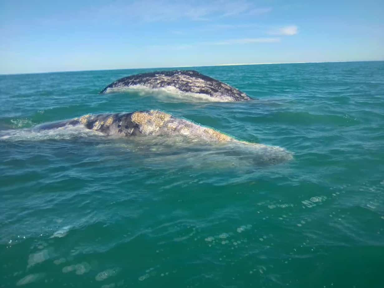
Ensenada is a Mexican port city on the Pacific side of the Baja California peninsula. In the middle of the port and in the area of the Malecón coast are the seafood market and the promenade. The Museum of History and the Regional Historical Museum of Ensenada present exhibitions on the history and inhabitants of the region. Migrating gray whales regularly visit this coast.
In the southwest of the city is the maritime geyser “La Bufadora”. La Bufadora is often referred to as a sea geyser, but it is not a hot spring. It is created when the waves of the sea push the water towards an underground cave. This creates a pressure that explodes when the water recedes. The fountain roars out and reaches a height of up to 28 meters.
Ensenada is the starting point for the Baja 1,000 rally, which ends at least 1,000 miles in Cabo San Lucas and takes place in November. The Baja 500 started here too, but ends after 500 miles in Ensenada. It takes place in June.
Ensenada’s diversity is due to Spanish, Russian and American influence. Spanish missionaries and Russian settlers first cultivated wine here and laid the foundation for today’s wine industry.
It is said that the Jesuit father Juan de Ugarde planted the first vineyards in the Valle de Guadalupe. Olives and wine are traditionally grown here. Currently, about 90% of Mexican wine production comes from the valleys of the Valle de Guadalupe and its surroundings. Many local wine producers offer tours and tastings. Every August in Valle de Guadalupe and the city of Ensenada, the beginning of the grape harvest is celebrated with a two-week series of cultural and culinary events called Fiestas de la Vendimia. This event attracts people from all over the world.
Guerrero Negro was founded in 1954 by the American Daniel Ludwig who founded the salt extraction plant to supply the western United States. The salt extraction plant was installed on the shores of Ojo de Liebre lagoon. With around seven million tons of annual production, this salt mine is the largest in the world. This company has created employment for a large number of people giving Guerrero Negro prosperity, but at the same time the hot and salty climate is not tolerable for everyone in the long term.
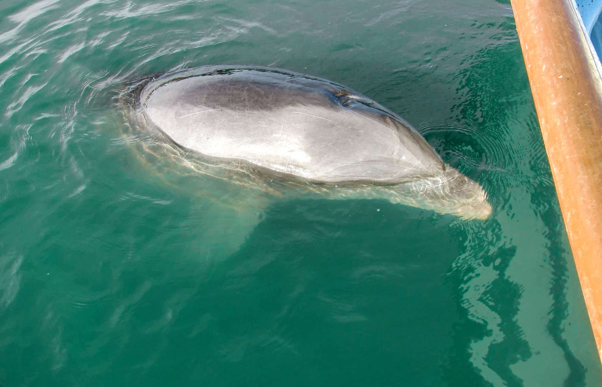
Besides the salt flats, the second main attraction is the “Laguna Ojo de Liebre” located to the south-west, which is home to hundreds of gray whales between January and March. A unique experience where you can appreciate the gray whales swim up close as they approach the small boats that are on excursion.
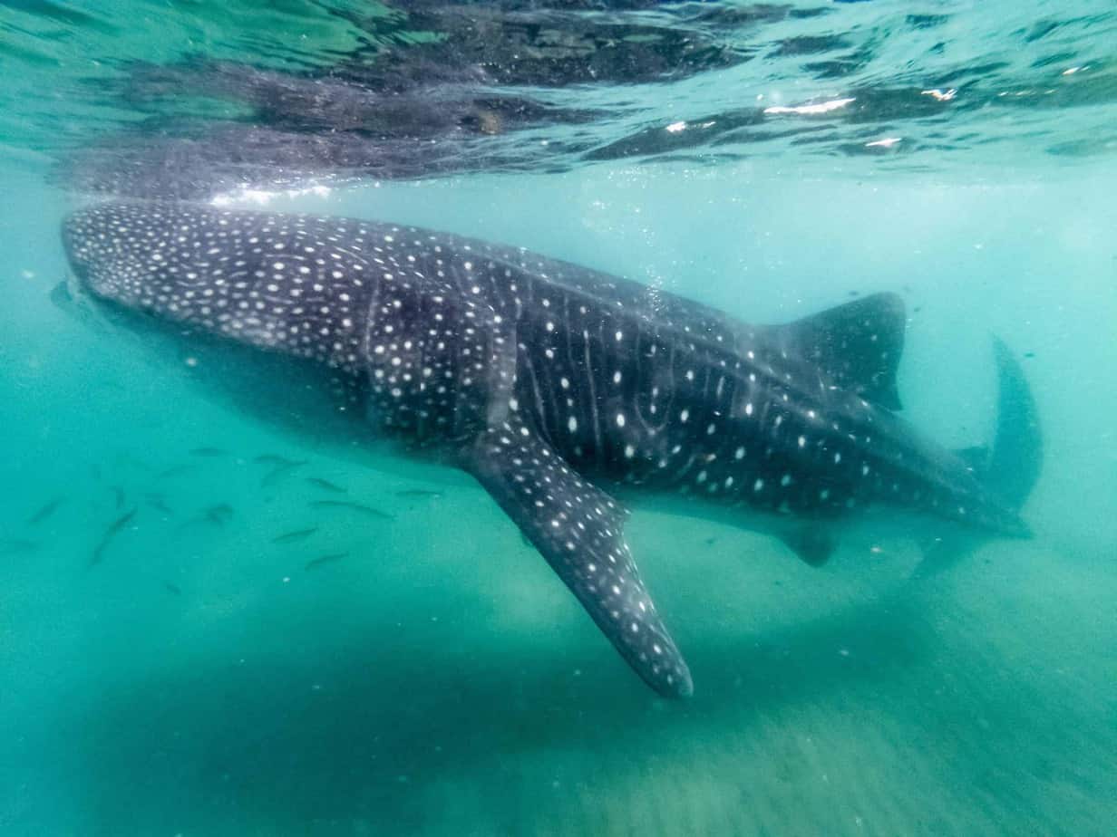
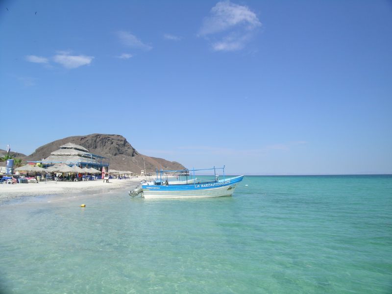
La Paz is located in the southeast of Baja California on the “Mar de Cortés”, the famous oceanographer Jacques Costeau named it the “largest aquarium in the world”. The diversity of the underwater fauna and flora make this place a paradise for divers, perhaps one of the best places in the world.
A short distance from the city you can find secluded beaches, quiet bays and pristine islands. Inland you can discover deserts, oases, mountains and lagoons. The virgin, natural environment attracts sport fishermen, divers, ecology tourists, naturalists, whale watchers and travelers of all ages to this peaceful corner of Mexico.
La Paz is a cozy town famous for its picturesque sunsets. Stroll along the waterfront, the Malecón, and visit the plaza with the cathedral
In addition, La Paz is the capital of the state “Baja California del Sur” and despite its relative tranquility with over 210,000 inhabitants, It is the most import place in southern Baja California.
Loreto was founded in 1697 by the Jesuit Juan Maria de Salvatierra, it was the first and thus the oldest Spanish settlement in all of California. Loreto has an international airport with connections to several Mexican cities and daily flights to Los Angeles. Around Loreto there are cactus deserts, and select places for fishing and diving that are the main tourist attractions of the place.
In 1996 Loreto was declared a nature reserve, due to its unique ecosystem. Loreto is also home to more than 160 species of algae, octopus, clams, snails and marine mammals.
Loreto was also the oldest religious center in all of Spanish California, spreading to what is now the US state of Oregon. On a tour of the quiet downtown, you will visit the mission and the Museum.
Loreto with a little over 12,000 inhabitants is a small “Magic Town” that still transmits the spirit of the Spanish colonial era. It is a very clean and wll-kept city.
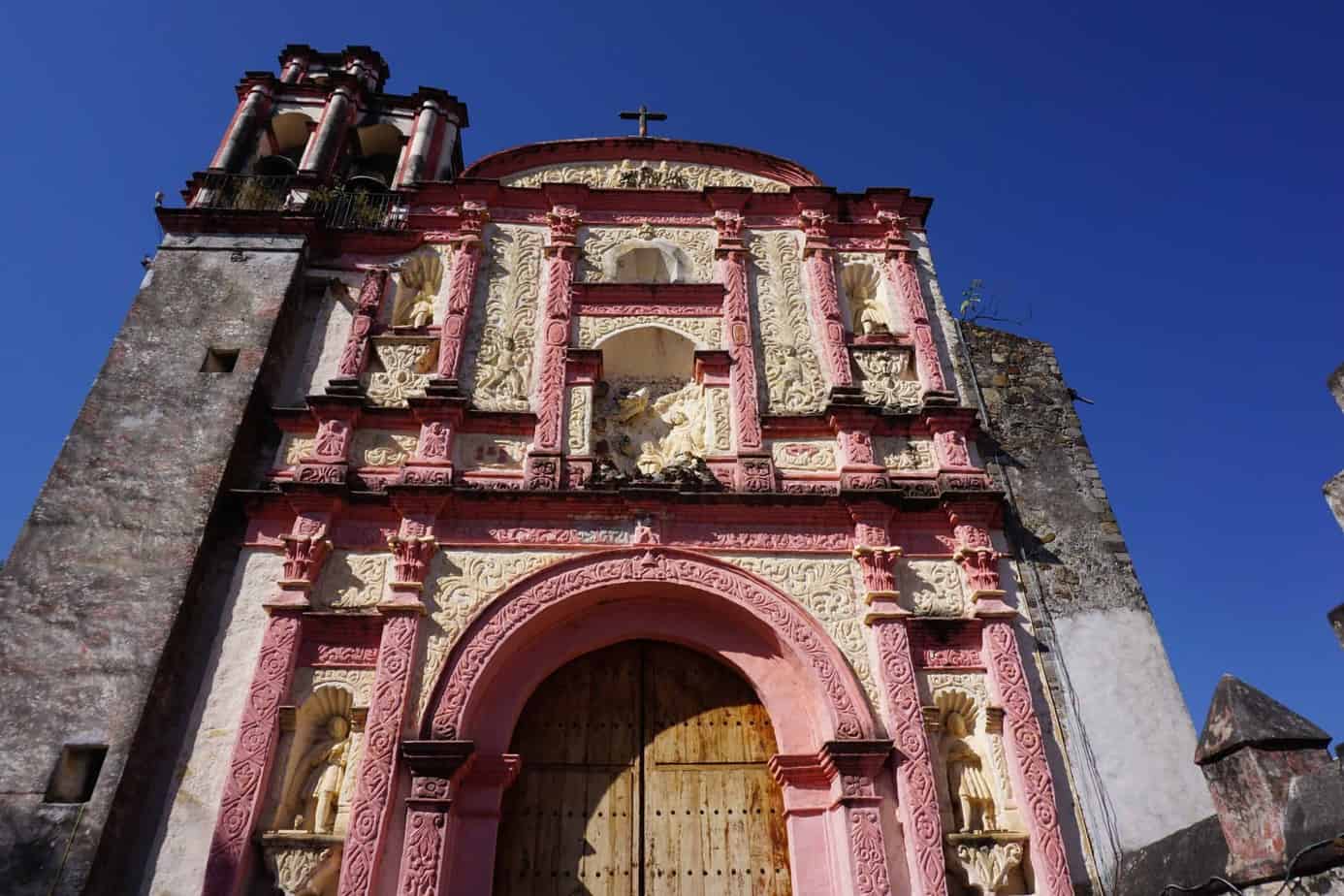
Don’t miss a visit to the Mission of San Francisco Javier which is located 35 km between the mountains. The Mission, founded by Jesuits in 1699, is located in a picturesque valley. It is considered the best preserved mission in Baja California.
Visit the oasis of Mulegé which is surrounded by the Santa Rosalía river. It has around 3,300 inhabitants and a tropical climate, where all kinds of fruits and agricultural products are found throughout the year. From the viewpoint behind the Mission church, there is a beautiful view of the oasis surrounded by thousands of palm trees.
The beautiful beaches south of Mulege in the Bahia de Concepción are very impressive. They are considered the most beautiful beaches in the Baja. Crystal-clear water and picturesque bays facing the mountainous landscape form a magnificent coliseum that invite you to practice water sports such as kayaking.
This natural oasis is located between Guerrero Negro and Santa Rosalía. In 1728 the Jesuit Juan Bautista Loyando established a mission here to evangelize the Cochimí Indigenous.
The mission and the plaza are part of the center of the small and quiet town, which has a colonial feel and is home to a few hundred inhabitants.
Around the oasis, various plants and animal species in a green forest and palm trees delight the eye and the San Ignacio underground river emerges here, all this makes an unreal contrast with the desert landscape of Baja California.
Santa Rosalia was founded around 1885 by a French mining company to extract copper. The view of the old buildings with wooden balconies and wide terraces at the “Mesa Francesa” transports you to colonial France. Particularly worth seeing is a steel church that Gustave Eiffel (the builder of the Eiffel Tower) designed in 1884 and which was brought to Santa Rosalia by the French mine owners.
After the mine was closed in recent years, it has seen a notable increase in extraction in recent years thanks to new mining techniques and is currently offering several hundred jobs again.
Santa Rosalia also has one of two Baja California ferry connections with Mexico: From Guaymas in the state of Sonora there are regular departures.
Todos Santos is located in the Tropic of Cancer – this is the northernmost degree of latitude where the sun is perpendicular to the earth on the solstice in June. The Guaycura and Pericues peoples originally settled in this privileged place. These important cultures lived in the south of the peninsula and were later evangelized by the Jesuits.
Todos Santos was founded in 1723 and is located on a plateau at the foot of the Sierra Laguna (pine and coniferous forest) and is surrounded by the Pacific Ocean. This tropical paradise is the most fertile place in southern Baja California. Here several sugar mills were located, an important economic factor for the region.
During the 100 year boom, beautiful buildings, houses and a magnificent theater were built. However, due to overexploitation of water, drought, and collapsing sugar prices, the economy collapsed in the 1950s. Todos Santos fell into a slumber, from which emerging tourism awakened in the early 1980s.
This beautiful and enigmatic oasis hides inside a true Magic Town: a place full of legends and a source of inspiration for artists and poets. Therefore, you will find galleries everywhere that appeal to the most discerning art lovers. Here you will also find first-class restaurants, quaint cafes and luxury hotels. As you walk, look at the roofs of the houses and count the sculptures designed to protect your roommates.
The main attractions include:
- The mission of our Mrs. del Pilar, which was built in the 18th century
- The theater “Grail. Manuel Márquez de León”
- The XXI Century Cultural Center
- The California Hotel
A must see in Todos Santos is the Hotel California, the inspiration for the world famous song “Eagles”.
Todos Santos has picturesque and quiet beaches such as Los Cerritos, La Lobera, San Pedrito, Punta Lobos, Pescadero, Batenquitos, La Poza and Los Esteros, which are particularly ideal for surfing, sport fishing and sea turtle watching.
Southern Mexico
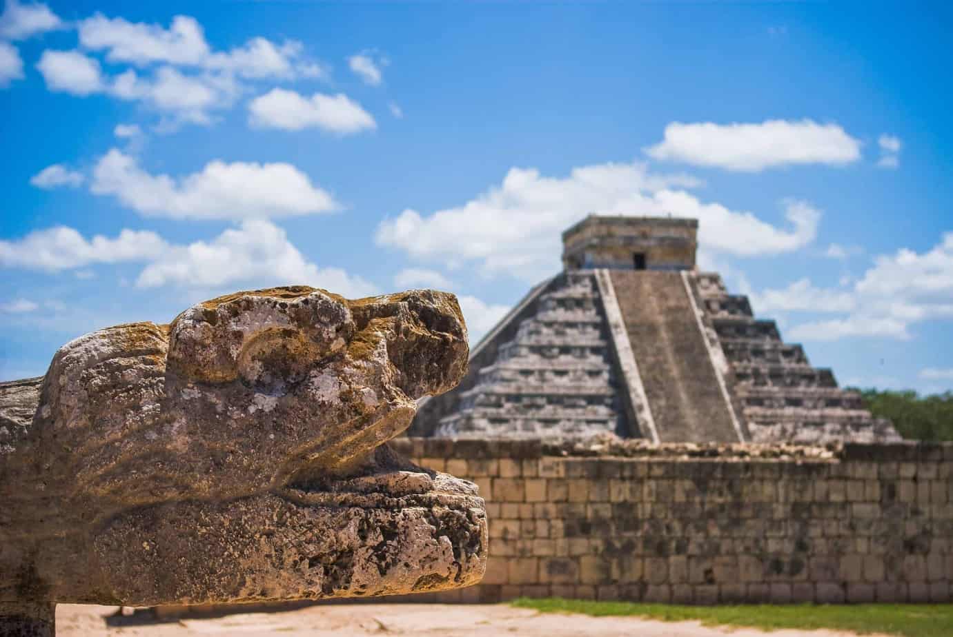
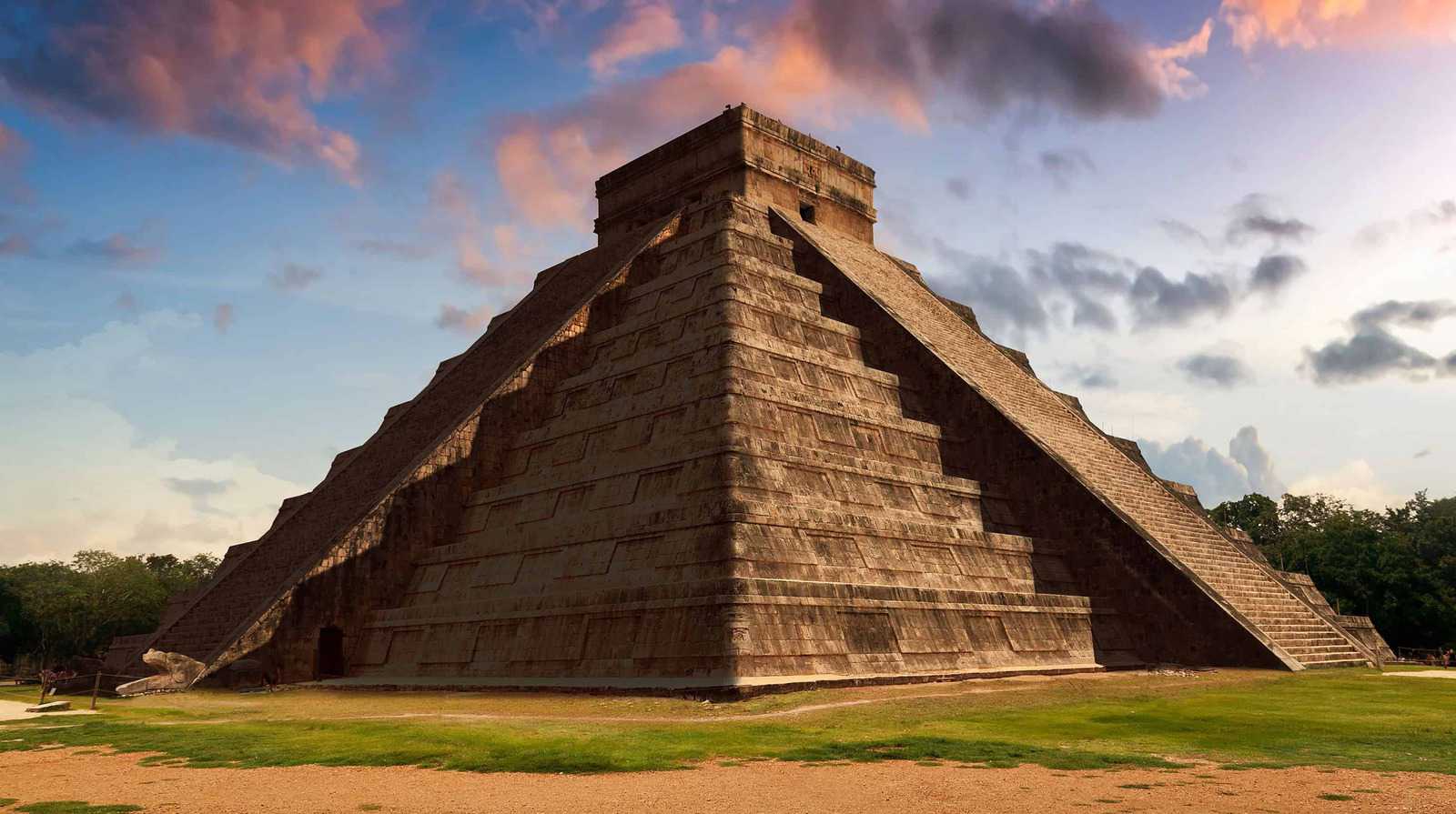
Chichen-Itza
Chichen-Itza is the most famous and best restored Mayan site on the peninsula. It was declared a World Heritage Site in 1988 and one of the seven wonders of the world. Both Chichen-Itza and Tulum are the most visited ruins in all of Mexico.
This archaeological city is located on the Mexican Yucatan peninsula, about 120 km east of Mérida. The Maya culture reached its peak around 600 AD until the 13th century.
The snake appears at the equinox
There is a particularly large crowd in Chichen-Itza on the equinox in the spring on 20/21 March and fall on 21/22. September. The sunlight creates the illusion that a snake is going up and down the stairs of the pyramid “El Castillo” in the morning and in the afternoon from light to shadow. The stair are adorned with the feathered serpent and the door frames at the top of the temple show Toltec warriors.
“El Castillo” is also called the Kukulkan pyramid and is a typical building of Mayan architecture: there is Mayan stone calendar.
Mayan stone calendar and other sights
Other places of interest besides the great Kukulkan pyramid are:
- The round observatory
- The ball playground (Ball Game)
- The warrior temple
- The convent of the sisters
- The group of a thousand columns
The only structure that you can enter or climb is the Kukulcan pyramid.
The best time to visit Chitzen Itza
The main dry season is generally dry months from December to May. The weather is consistently hot and humid, and the temperatures only drop slightly between November and February. During the rainy season (from June to September) there are violent tropical rains.
Monte Alban
The ancient Zapotec capital is located a few kilometers west of Oaxaca. It is one of the most impressive historical sites in all of Mexico and was listed as a UNESCO World Heritage Site in 1987. The name means “White Mountain”.
Monte Albán is located approximately 2,000m above sea level with the top of the mountain flattened artificially and was the religious center of the Zapotecs, later the Mixtec. The first people to live here around 500 BC. Were most probably Zapotecs. It is believed that there were cultural ties to the Olmecs in the northeast.
Monte Albán’s history is divided into five different phases:
- Monte Albán I: around 200 BC The hilltop was leveled and temples and palaces were built on it. About 10,000 inhabitants had settled on the mountain flanks. During this time, hieroglyphs and dates were recorded in a kind of coordinate system, proof that Monte Albán was the first place in Mexico to use writing and a written calendar.
- Monte Albán II: The city stretched between 200 BC and 300 AC their influence on all of Oaxaca. The buildings of this phase consisted of huge stone blocks and had steep walls.
- Monte Albán III: Its peak was between 300 and 700 BC. Terraces were created on the main hill to build houses for the approximately 25,000 inhabitants. Most of the remains date from this period. Many buildings were plastered and painted red. At that time, Monte Albán was the center of a highly organized society in which priests were in charge.
- Monte Alban IV: Between 700 and 950 BC, the city was abandoned and it turned into a landscape of ruins.
- Monte Albán V: (950-1521) During this time the city was still deserted. Only the Mixtecs from northwestern Oaxaca used the ancient tombs to bury their own dignitaries.
The Gran Plaza, the ball court and the tombs are some of the place of interesting.
The state of Oaxaca is a melting pot of different languages and indigenous groups, which in addition to the gastronomic, landscape and maritime diversity make it an interesting tourist destination time and time again.
With its historical and cultural richness, Oaxaca is a fascinating tourist destination where ancient civilizations, colonial architecture and living tradition come together. Its culture and the warmth of its inhabitants are the main reasons for a trip to Oaxaca so that this region works its magic in all its senses.
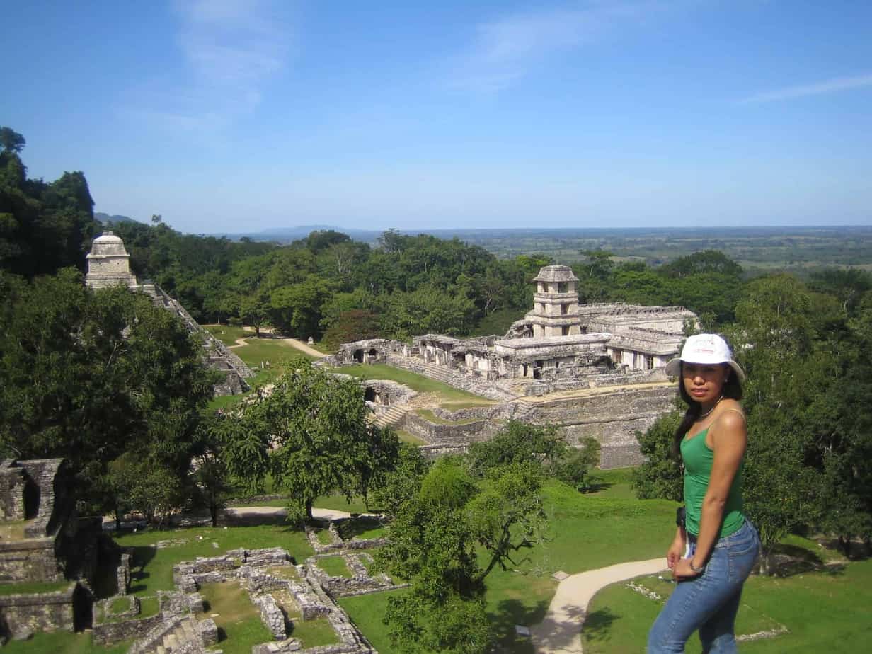
Palenque
Embedded in the rainforest are the ruins of Palenque, probably the most impressive of all classic Mayan sites in southern Mexico. These archaeological ruins are located in the state of Chiapas, about 8 km outside the town of Palenque, also known as Santo Domingo de Palenque.
The Palenque Mayan metropolis has been a UNESCO World Heritage Site since 1987. The small town is located below the Usumacinta river. Numerous small streams flow through the archaeological area of Palenque. The ruins, for which artificial terraces were often created, stand against the green hills of the highlands, which have been integrated into the architecture of the city. So far only about 5 percent of the buildings have been discovered, the rest are still covered by the jungle.
The name Palenque means big water. It was used for the first time around 100 BC. And it peaked around 630 to 740 AC. Under Pakal rule (615-683), the city became famous. Pakal was represented in the hieroglyphs by the sun and the shield. Many buildings were built in Palenque during the reign of Pakal. One of them is the great Temple of the Inscriptions “Pakals Mausoleum”. The stepped pyramid is about twenty meters high and has a small temple on its roof platform. The burial chamber has an area of four by ten meters and is around seven meters high. Climbing the step pyramid is no longer allowed for tourists.
The palace is diagonally opposite the “Temple of Inscriptions”, a large building with a labyrinth of corridors and rooms. To the northeast is the Patio de los Cautivos. It contains a collection of relief sculptures that look a bit lage for their surroundings. They represent the captured rulers who were brought here. The ruins of the Grupo de las Cruces, el Templo del Sol and Southern Acropolis are also in this complex area.
When exploring the pyramids, they imagine the stone buildings as they looked when Palenque reached the peak of its power: painted red with ornate blue and yellow stucco details. The forest around the temples is still home to howler monkeys, toucans and ocelots.
If you want to see all destinations in the near and far surroundings (Palenque ruins, Agua Azul, Misol Ha, yaxchilan and Bonampak), it takes 2 to 3 days. The ruins of Palenque, Agua Azul and Misol Há can also be visited in one day. Yaxchilan and Bonampak can also be visited on another day.
In Palenque the weather is very hot and humid, so it is recommended to start the excursions very early: it is cooler and not as crowded. In addition, the morning mist envelops the ruins in a picturesque haze. In any case, you should bring sun protection!
Tulum
Tulum is located about 55 km south of Playa del Carmen, in the so-called Riviera Maya, a coastal strip on the Caribbean coast of Quintana Roo. One of the places you cannot miss in Tulum are the Mayan ruins, which are located on the cliffs above the Caribbean.
In Mayathan, Tulum means “wall” or “fortress”. Tulum’s former name was zamá, which means “dawn”. The city was once a commercial and also a religious center and above all an important Mayan seaport. A massive wall over 4 m high and a total of 600 m long surrounds the 380 y / 170 m large area, in which there are about 50 temples(houses) and remains of palaces (smaller)
Tulum has been declared a World Heritage Site by UNESCO. Accompanied by warm starry nights and turquoise sea, the archaeological site rises on the sea shore. All that remains of the great Mayan city is the temple district with the palace. Other buildings include the “Templo del Dios Descendente” (descending God) and the Templo de los Frescos (frescoed temple) and the Templo de los vientos (Temple of the Wind).
The well-preserved ruins of Tulum are remarkable, but their unique location is almost even more impressive. The greyish-brown buildings rise above a beach surrounded by palm trees and turquoise water. You should not expect to find the same architecture here as in Chichen-Itza or Uxmal. The buildings in Tulum are undoubtedly of Toltec influence and are the product of a Mayan culture that was already in decline. The city center is surrounded by a wall open to the sea, with watchtowers on the northwest and southwest corners. For reasons of monument conservation, not all ruins are accessible to visitors. The site was built to observe the starry sky, especially Venus. The Mayan calendar was created in such places and was constantly verified.
Tulum had its heyday in the postclassical period from 1200-1400 BC. However, the first traces of settlement come from much earlier periods, the oldest evidence being a stellar find dating back to the year 564. Tulum was the easternmost outpost of the Yucatecan Mayan region and when the Spaniards arrived one of the last intact Mayan cities left on the coast.
Top attractions in the area include snorkeling and diving. Not only the fantastic reefs are tempting, but also the diverse and mysterious underwater caves and cenotes that are becoming more and more.
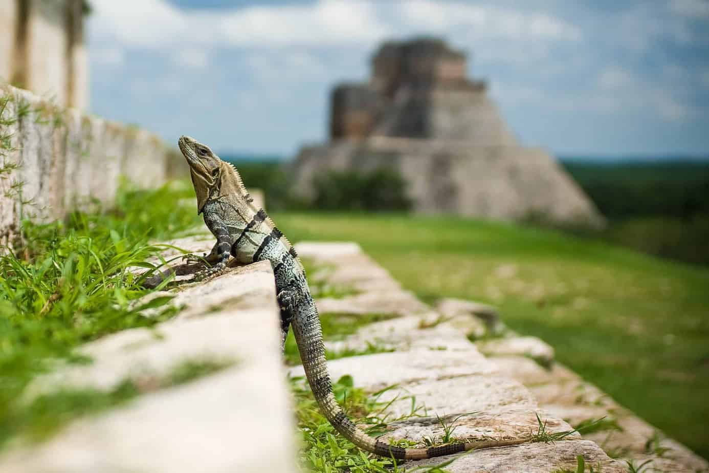
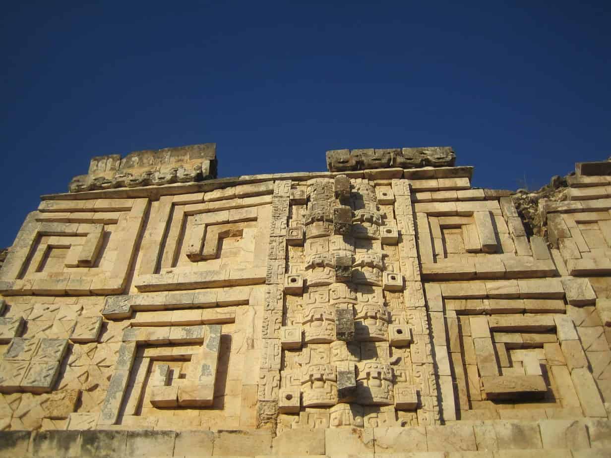
Uxmal is about 80 km southwest of Mérida and with Chichen-Itza, is the most important of all the Mayan sites on the Yucatan Peninsula. The name is derived from the Zukatekan Mayan language and means “three times”. Uxmal was named a World Heritage Site by UNESCO.
The first traces of Uxmal can be traced back to 400 BC. can be traced. The city-state experienced its heyday as an economic and religious center between 800 BC and 1000. During this time, Uxmal was the dominant urban center of the region, comparable to Chichen-Itzá du Mayapán. All larger buildings were built around 900. At that time, around 20,000 people lived in Uxmal. After the Toltec invasion of the Yucatec peninsula, Uxmal was abandoned at 1,200.
The most famous building of Uxmal, the massive, 38 m high pyramid of “magic” or “fortune teller” (the name comes from a local legend, according to which the pyramid was built by a magician in a single night) stands out on the access path. The pyramid has an oval plan that is unusual in the Maya world. The rounded edges are reminiscent of the round walls of typical Mayan huts. This pyramid is the result of five superstructures (cladding) of buildings and previous periods. It is the third highest on the Yucatán peninsula with 117 steps that climb that rise steeply without an intermediate landing.
The buildings are dominated by the Piramide del Adivinador “Pyramid of the Wizard”, which like most buildings in Uxmal was repeatedly rebuilt and expanded during the settlement of the city. The most famous building is the so-called Governor’s Palace, which is located on a high platform. Uxmal is now one of the most visited Mayan ruins and offers a good insight into the original appearance of the city through the restoration of buildings.
Here you can also see other ruins: The Quadrangle of Birds, the Quadrangle of Nuns, the Turtle House,Palace of the governor, the Great Pyramid. At 30m high, the latter is only slightly lower than the pyramid of the magician. The dovecote of this ruined complex is older than the other buildings in Uxmal. Only one wall remains of him.
Next to this installation there is a small museum with finds from Uxmal, such as steles, ball play area, ceramics, etc. Every night there is a sound and light show in the plaza de las Monjas (north temple). The buildings of Uxmal are illuminated in alternating colors by spotlights, wich dramatically combine narratives and music. The radio play portrays the history of Uxmal, the lives of its inhabitants and rulers, the wars and the invocation of Chaak to make it rain.
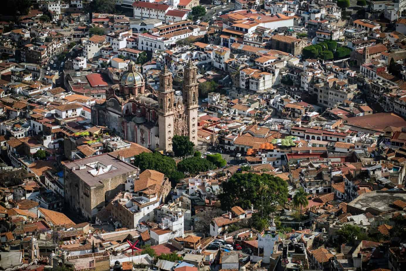
Colonial cities
Magical Towns
There are many unknown but fascinating places in Mexico that offer relaxation and adventure to tourists from all over the world. These include the Pueblos Mágicos “magical towns”. These are places that are characterized by their beauty and a particularly prosperous cultural and historical heritage.
To help these small magical places become more touristy, the Mexican government has started a project and has been promoting the “Pueblos Mágicos” program since 2001. The award is particularly intended for small towns that have preserved their unique architectural style from the colonial period. Other local structures, such as the villages of the Tarahumara Indigenous, are promoted through the nation’s native heritage program. Taken together, all measures give the traveler a variety of impressions of shapes, colors and scents, for which Mexico is known worldwide.
In addition to their historical and cultural importance, these small towns offer modern hotels and transport links. The administration and the residents work together to provide a warm welcome culture and good service. These special support programs are not only a commercial benefit for the residents, but also offer them the opportunity to actively get in touch with tourists from different countries.
The “Pueblos Mágicos” program currently comprises 83 places that are particularly worth seeing. You can visit three of them on your train trip in the Sierra Tarahumara: El Fuerte, Creel and Batopilas.
Only the streets and houses of these magical places are places of interest, but there is much more to discover. We invite you to explore these cities for yourself!
At El Fuerte, for example, you can try the handmade flour tortillas during a walk around town. For a boat trip, please meet shortly after breakfast in the hotel lobby. Downriver with big inflatable boats. You can observe the great variety of endemic bird and plant species on the banks of the El Fuerte River. A visit to the ancient wall inscriptions and petroglyph stones on a small hill (“El Cerro de la Mascara”) is included. This place contains about 45 stones, which together have over 100 engravings. The petroglyphs are between 800 and 2,500 years old.
In Creel, an adventure awaits you at the nearby waterfalls, where you can refresh yourself in the bubbling water. A hike through an impressive landscape with a number of surrealistic rock formations. In the “Valley of Mushrooms” and “Valley of the Frogs” bizarre stone shapes live up to their name. Vertical stone pillars stand in the “Valley of the Monks” and are worshiped by the Rarámuri as symbols of fertility.
In Batopilas visit one of the most popular hikes which leads to Cathedral Perdida “the missing cathedral” in Satevo. This artistic church was discovered in the 18th century. in a remote and uninhabited canyon. To get to this church you have to walk 8 kilometers or 20 minutes. Other places of interest in the Batopilas area are also worth a visit.
Guanajuato: a colonial jewel named by UNESCO in 1988 as a Cultural Heritage of Humanity. It was the most important mining center in New Spain.
It has great monuments, alleys and a network of tunnels underneath the city knows the Museum of the Mummies of Guanajuato, the historic center, the mines and the University of Guanajuato which has an astronomical observatory on its roof.
Guanajuato is famous for its Cervantino festival with theater shows, musicals with serenades and “callejoneadas”
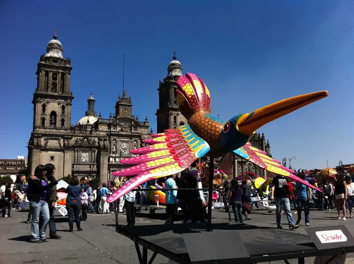
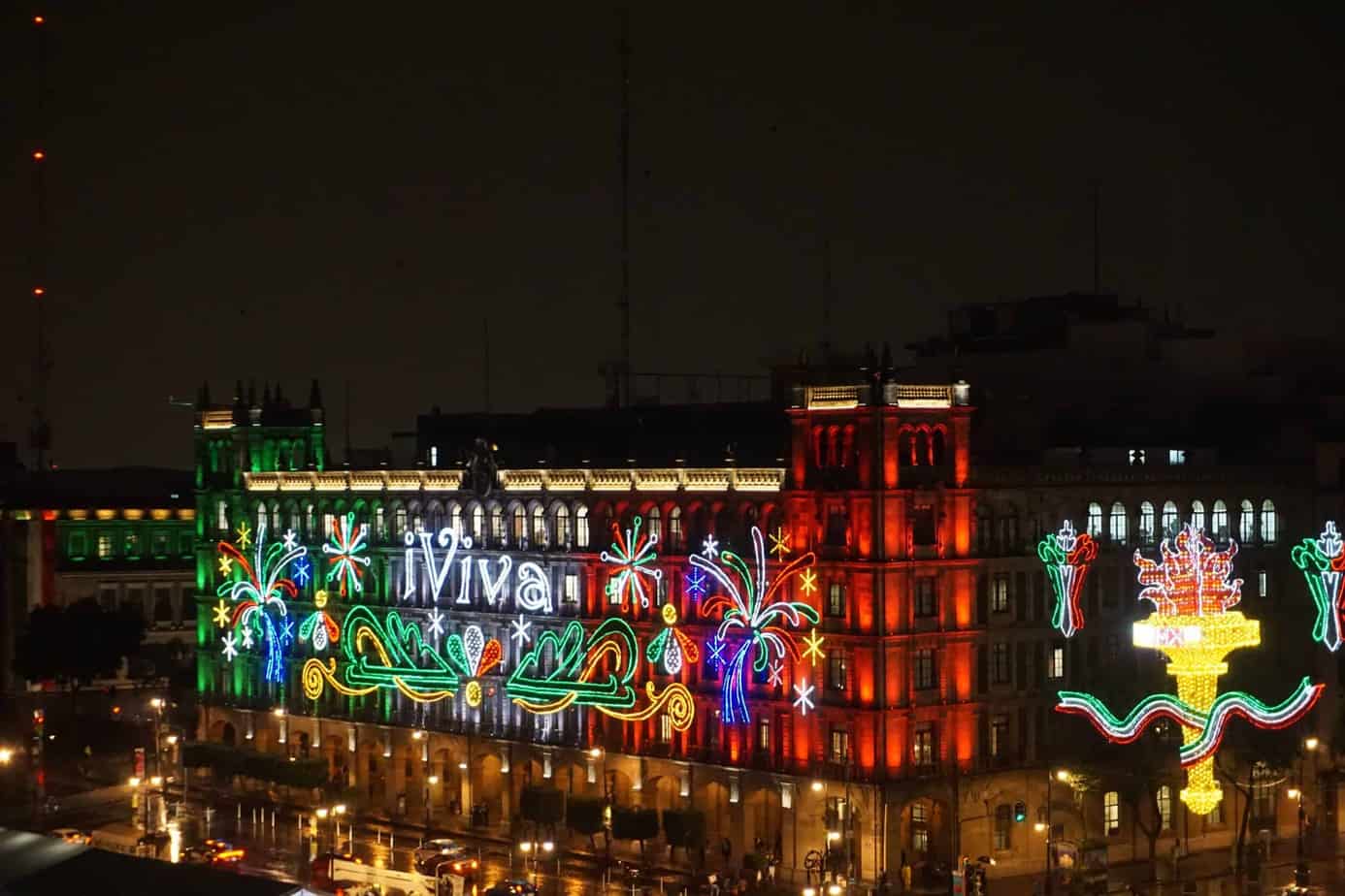
Mexico City: It is the political and economic center of the entire country. In the historic center of the city is the esplanade of the Zocalo, the third largest in the world. We can also find the National Palace in which are the murals of Diego Rivera where he captured the most important moments in the history of the nation. Behind the cathedral we can find the “Templo Mayor of Huitzilopochtli”, which was a ceremonial site of the Aztecs. Currently it is a museum that shows the ancient Tenochtitlán. In the surroundings of the Zocalo there are colonial buildings: “Estanquillo” museum, The Iturbide Palace, House of tiles, Mining Palace and Post Office.
A few meters away we will find in the Alameda Square the impressive Palace of Fine Arts and the Latin American Tower.
Some of the most important places to visit are the “Plaza de la República” with the monument of the Revolution where the remains of some presidents such as Francisco I. Madero, Plutarco Elías Calles, Lázaro Cárdenas, Gral. Francisco Villa are found.
It is also worth visiting the Angel of Independence, the University City and the Bosque de Chapultepec within which are some museums, the zoo and Lake Chapultepec. You cannot miss visiting Lake Xochimilco and taking a ride on its colorful trajineras.
SPECIAL EVENTS
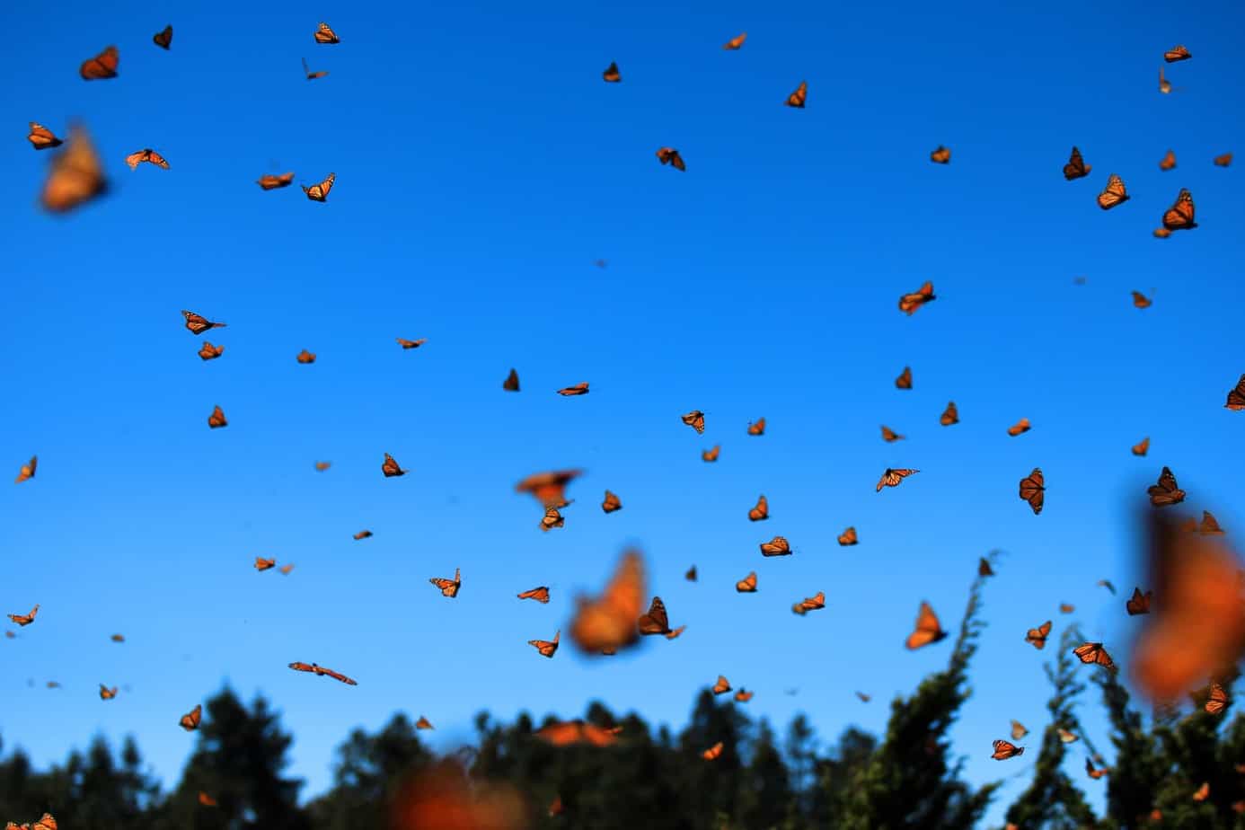
Monarch butterfly migration
The migration of the monarch butterfly is a spectacular event that is repeated year after year between the end of October and the beginning of November: around this time, millions of monarch butterflies fly from the Great Lakes region in the United States and Canada, to 4,500 kilometers away, into the wooded Mexican highlands. Here, in the Monarch Butterfly Biosphere Reserve, on the border between the states of Michoacán and Mexico City, they hibernate.
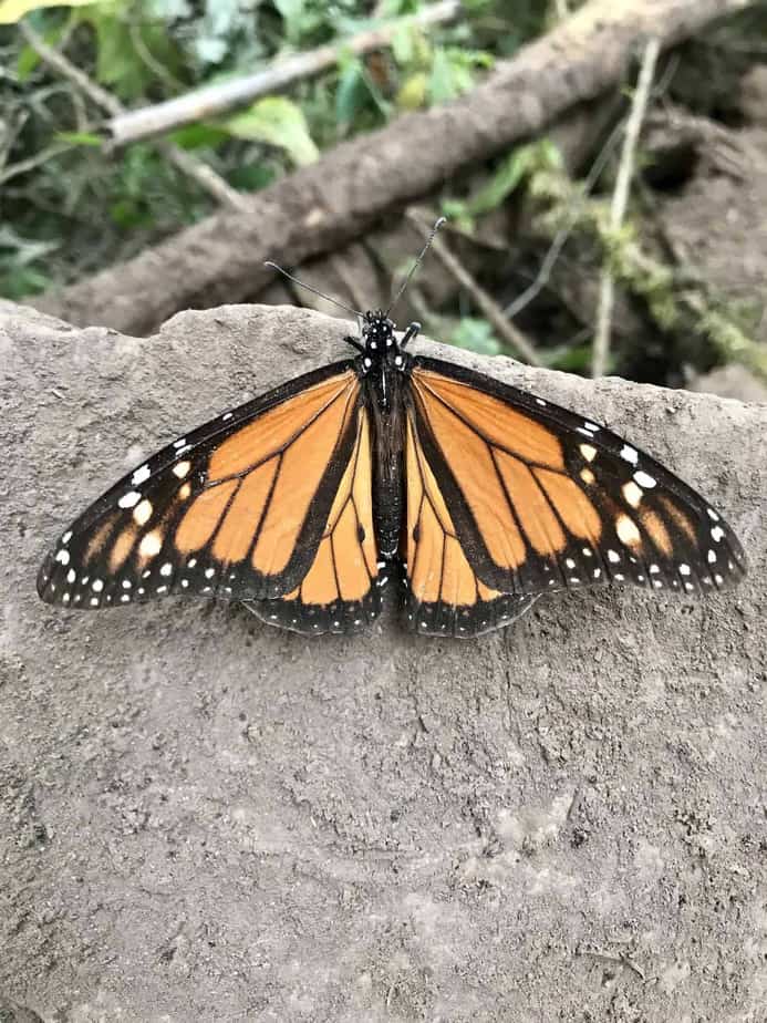
Monarch butterflies are of great beauty and color. As pollinators, they play an important role in ecological balance and are of crucial importance in the life cycle of forests. Orange insects with black grid lines differ from their colleagues in their longevity: while other butterflies have a 24-day life cycle, monarchs can live up to 9 months.
The wings have an easily recognizable orange-black pattern with a wingspan of 8 to 12 cm, so there are fundamental differences between males and females:
- Female monarch butterflies have darker wings and the black stripes on the wings are wider.
- Slightly larger male wings have thinner stripes compared to females, and a black dot can be seen on each of the hind wings that releases pheromones.
It’s hard to say how many eggs female monarchs will lay in their lifetime, but the average in their natural habitat is estimated at 300 to 400 eggs.
On the journey to and during their stay in Mexico, the adult specimens mate, lay eggs, and the generation is born that will fly to the United States and Canada next March. None of them will return to Mexico as their life cycle is only a few weeks.
When the butterflies approach their destination, they gather in large flocks, crossing roads, and climbing the steep slopes of the mountains. At dawn they rise into the sky like golden and orange clouds. They spend the hottest part of the day on the moist soils of the forest. The best time to see them is a warm, sunny afternoon, when they have covered the floor like a shiny carpet. They are slow on cold days. Amapa Tours shows you the best places where you can experience this show in the middle of the beautiful nature of Michoacán.
The Monarch Butterfly Biosphere Reserve has been one of four natural beauties recognized as a UNESCO World Heritage Site since 2008.
Equinox at Chitzen Itza
Experience the equinox at Chichén Itzá – the day the feathered serpent slips away.
The equinox is the two days of the year when the day and night are exactly the same length, indicating the transition from winter to spring and from summer to fall. This applies to all places on earth. The sun rises almost exactly in the east or sets in the west on those days all over the world.
The Chichén Itzá ruins are one of the most visited places to appreciate this phenomenon. Every year, thousands of people gather at the Kukulcán pyramid to marvel at the appearance of the feathered serpent and celebrate together in spring or fall.
When the sun sets around 4 p.m., the show begins: the play of light and shadow between the sun and the nine steps of the pyramid casts a bright, curved band on the outside of the pyramid staircase, gradually move down and then for a brief moment with the stone snake head. attached to the foot of the pyramid. The rest of the side of the pyramid is in shadow. This creates the visual impression that the snake would slide down the steps of the place of worship. After about 30 minutes, the body of Quetzalcoatl’s snake is clearly visible. The unique phenomenon lasts for a few minutes, then the snake dissolves and leaves viewers in awe.
In this magical and emotional moment, many people drop to their knees and extend their arms to absorb as much energy as possible.
The equinoxes fall on March 19, 20, or 21 (spring equinox) and September 22, 23, or 24 (autumn equinox). We invite you to experience this phenomenon with us.
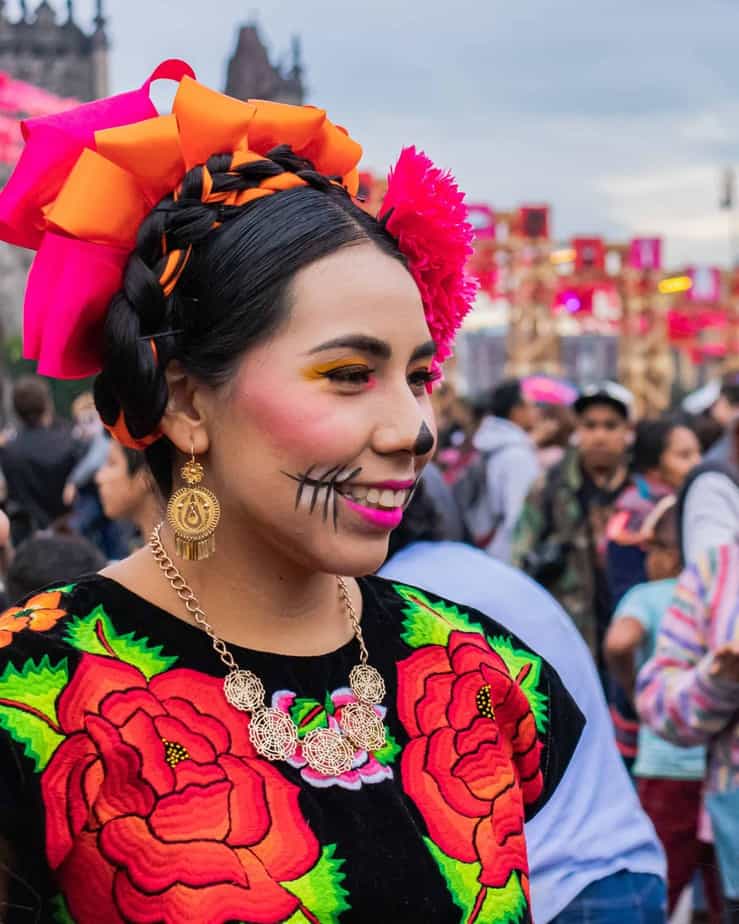
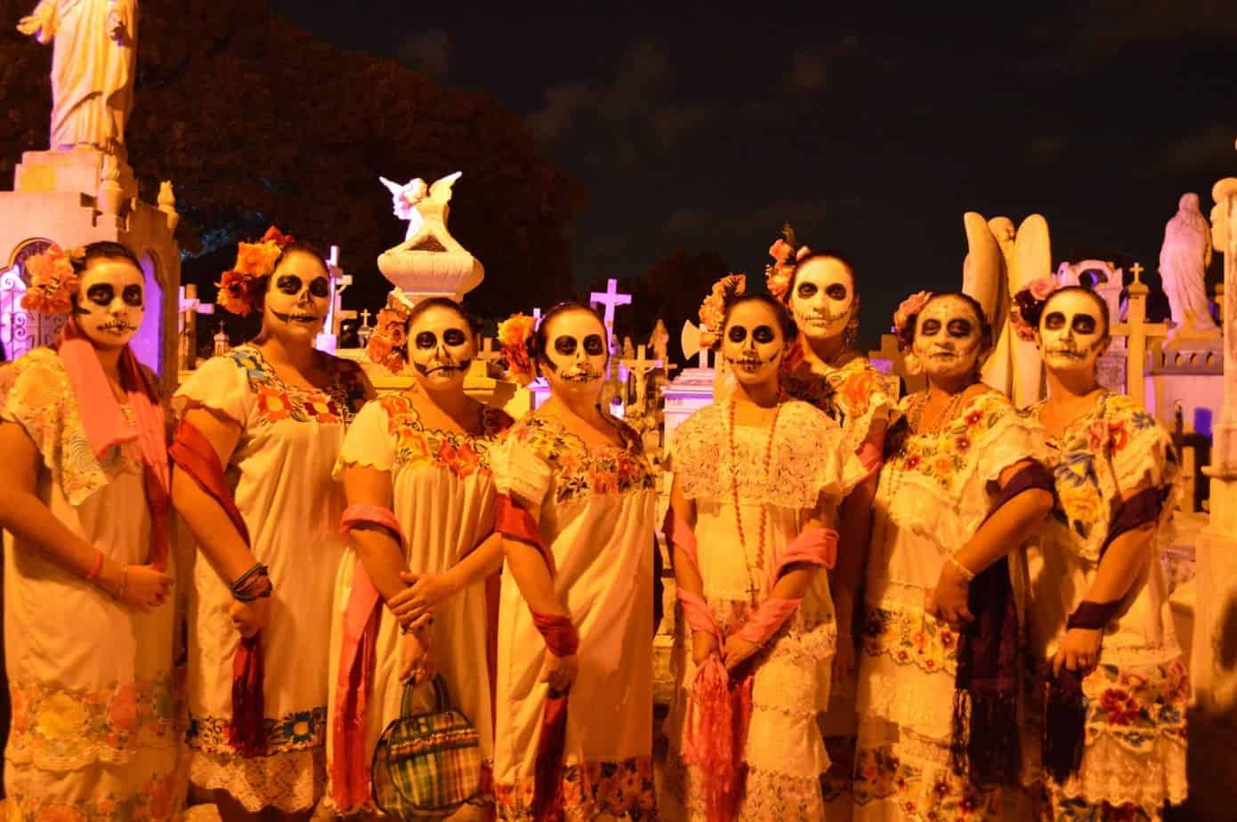
Day of the dead in Mexico
The Day of the Dead is one of the most important and beautiful holidays for all Mexicans. The celebrations for the deceased begin on October 31, the eve of All Saints’ Day, and run until the Day of the Dead on November 2. According to legend, on the day of the dead the angels (little angels) come to visit their relatives to celebrate with them.
The Day of the Dead is not a mourning event, but a colorful folk festival in honor of the deceased. According to ancient Mexican popular belief, the souls of the dead from beyond return to their families to visit them that day. During these days, the focus is on the memory of the deceased.
A happy gathering with music, dancing and good food is celebrated together with family or friends. Each family erects an altar in their apartment with flowers and photos of deceased relatives. They prepare dishes that they liked and listen to their favorite music. Offerings are built on altars in various stages. An image of the deceased, for whom the altar was built, is usually on the upper level.
On the second floor, objects that this person liked in life, food, toys, musical instruments, beer, tequila shots or cigarettes are placed. On the lowest level there are candles, figures of Santa María de Guadalupe or flowers. The altars are also decorated with colorful paper-cut garlands (usually with skulls). Common decorations are: the Pan de Muertos, the skull made of sugar (Calaveras de Azúcar) and the orange flower of the dead (Flor de Cempasuchíl).
Offerings can be found not only in Mexican homes, but also in cemeteries, where huge altars are erected on the Day of the Dead to honor famous people. Some streets or shops are decorated with flowers as a symbol of death. Everywhere you can see skeletons and skulls made of chocolate, amaranth or marzipan in shop windows, bearing the names of the dead on the front, to remember them.
In Mexico, death is not seen as the end of life, but, as the Aztecs believed, as a transition phase to another phase of life. In pre-Hispanic times, the Aztecs even gave their enemies a place where ghosts could return: in a wooden frame (Tzompantli), the skulls were perfectly aligned as a container for ghosts.
Spanish missionaries, who tried unsuccessfully to abolish the pagan festival, combined the celebrations with All Saints Day celebrations. The parallelism between the Christian concept of death and indigenous belief made this syncretism possible, allowing the customs of pre-Hispanic Mexico to live.
Mexico City celebrates the Day of the Dead with a gigantic parade. That day, around 1,000 people roam the streets. They disguise themselves as skeletons, as sugar or as the Lady Catrina – Death. A colorful show where you can feel closely the joy and tradition of the Mexicans.
In San Andrés de Mixquic, near Coyoacán, you can feel the spirit of the Day of the Dead everywhere. In the cemetery, all the chapels are decorated with flowers, so the church tower offers a magnificent view of the carpet of orange flowers and the many candles.
A small Catrina movement takes place in Coyoacán. The epitome of this celebration, La Catrinas is known around the world as a cult figure and serves as a costume to celebrate this day in many countries, including Spain. It is represented by a painted face that resembles a skull and is decorated with colorful flowers.
“Catrín” originally referred to an elegantly dressed man of the aristocracy, who was accompanied by a woman. La Catrina is a female character with more than 100 years of history, created by the Mexican cartoonist José Guadalupe Posada. It was first called “La Calavera Garbancera” and it was a mockery for the indigenous peoples who had become rich and had lost their origins and customs. Similarly, Calavera Catrina means: In death we are all equal. Later, the muralist Diego Rivera took over the motif for “La Catrina” and made it famous.
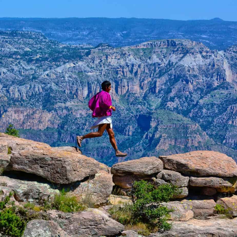
The ultra marathon “Caballo Blanco” (UMCB)
In this legendary Ultra Marathon, more than 80 kilometers are covered along the magnificent Urique Canyon. It takes place every year on the first Sunday in March and is undoubtedly one of the most picturesque marathons in the world.
The start is in the town of Urique, whose canyons of the same name extend up to 1,800 meters and are among the deepest in the Sierra Tarahumara.
More than 800 runners from the Copper Canyons, from various regions of Mexico and from around the world gather in front of Urique’s main square to join the indigenous Rarámuris hosts, also known as “those with light feet. Immerse yourself in an unforgettable adventure. The Tarahumara celebrate their way of life and culture and share their joy of running with others.
The first “White Horse” Ultra Marathon was in March 2003 organized by Michael Randall Hickman better known to the Rarámuris as Micah, which in the Rarámuri language means White Horse. I wanted to bring together runners from all over the world and promote the great culture of the Rarámuris (Tarahumara), support them and also the rural communities.
Endurance athletes from around the world are now participating in the ultra marathon and supporting local families in Rarámuris. Every race record helps.
The organizer of the Caballo Blanco Ultramarathon is the community of Urique, Chihuahua, Mexico, with the support of the Mas Locos association and friends from all over the world. The UMCB has an incredible history and is considered one of the most important events that all marathon runners should participate in.
Another highlight that weekend is the UMCB children’s race “La Carrera de los Caballitos”: the day before (Saturday) the day of the race, many Tarahumara children participate in short races in the city of Urique. This children’s event is a wonderful tradition that the next generation of runners is preparing for.
The mountains of the Sierra Madre have always forced the Tarahumara to walk a lot. In this way, they developed more and more stamina over time. Even today there are Rarámuris who run up to 170 km through the mountains without stopping.
Two of the best Rarámuri corridors in the region are:
Miguel Lara: He has won the Caballo Blanco Ultramarathon in the last three years.
Lorena Ramírez: A particularly talented runner who has won the Ultramarathon five times.